That sounds great! Give me a hint if you know which frequency and so on.
It’s the same Astra 3B frequency as last time: 11681.242 MHz
For the first few days, it will just be packets being sent out. The broadcast won’t be the same as SES-2 in the US because this beam is running at about half the speed.
Please put this on the thread for European coverage
I easily get confused
@Martin @Tysonpower If you are pointed, you should be receiving. Beam type 163. No files, just packets.
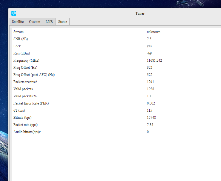
Signal is up and Running. Receiving it fine from Cologne, Germany.
Using DC3.03, cheap QuadLNB and a 60cm Dish indoors trough a double glasing Window.
Will do a LNB only test later.
1 Like
Same SNR as before with that setup?
Yeah around the Same, maybe a little bit more (1db or so)

I did some testing on the boat this weekend. I recieved some packets and the pointing was very stable. But I seem to have quite a bit of trouble with my azimuth, but thats the typical issue with steel boats I guess. In the berth between the riggs of all the boats I still had a SNR of around -11.5 once pointed correctly. But under way the signal was around -14. Still it recieved some packets although the azimuth was way off. I’ll do some more field testing here in southern Germany and I’ll figure out how to implement a deviation table for the use on the boat to compensate for the boats magnetic field. But I’m pretty confident after the first test to get it working reliably.
1 Like
Is the IMU/compass unit providing inaccurate bearing information?
Yes it is off by quite a few degrees. But that’s a perfectly normal thing on boats. You have the same with every magnetic compass. The boats own magnetic field interferes with the magnetic field of the earth. This interference varies depending on the heading you are steering and is different for every boat (and its stronger on steel boats like mine). So for navigation you use a deviation table to calculate your true heading from your magnetic one. I’ll try to make such a table to use with my unit.
Do product manufacturers that require bearing have other ways to compensate for this discrepancy, since there could be hundreds of these offset tables?
I don’t know how they deal with it. It’s really like that that every boat has its individual table. But since I have a GPS now, I could for example point the device exactly forward, when it is not in use and constantly read its bearing and compare it to the heading calculated by the GPS. From the difference you could get a deviation table after some time, when you steered in all directions. So there would be an initial calibration period after setting up the unit on a boat and after that it should know its specific deviation for each heading.
If your IMU is not calibrated you will have always that problem. To get true heading you have to deal with deviation (magnetic heading + deviation) and variation (magnetic distortions produced by your boat structure and components). You can calculate deviation easily if you know your position but you need calibrate the IMU to compensate variation. In openplotter we use pypilot project to continuously calibrate the IMU. pypilot is a python tool and if I am not wrong you are using arduino. You will need at least a raspberry pi zero to run pypilot and get true heading.
1 Like
@Sailoog I’m sorry if I mix something, I learned this with the german terms and am not familiar with the english terminology. And in german the table for the boat is called a deviation table. I thought it is the other way round (variation = difference between true and magnetic and deviation = the error caused by the boats magnetic field)
And I have a Zero lying around still.But I also want to set up a raspberry pi 4 on my boat with openplotter to share the GPS and AIS data with my tablet running openCPN. By the way, you did amazing work with your project!
@Martin, you could be right, I have also learned this in Catalan and it is the same in German but I always see the opposite in English 
Keep working on this please!! AFAIK no one is working on something similar and it would be really amazing to make it work.
I have an idea. Why not leaving the hard work of calculating the true heading to OpenPlotter using its IMU and send data to your device by wifi? It is everything already done in OP, you should just connect to its access point. Maybe you could even remove the IMU from your system if both devices are more or less leveled and aligned and we achieve enough rate for pitch and roll.
Just curious how this works, Do you drive a bunch of circles and set something using a range bearing ? and I have been running opencpn for years with my ais receiver, it’s familiar to me so I just making it work. The automated chart-downloader is why I started using it.
Files are coming down now.
1 Like
@Martin How high up does the compass need to be on a boat in order to avoid the magnetic field of the boat?
Sorry for the late answer, I was away for a week. I guess it should be at least 1 m away from all metal parts. I have a fluxgate compass installed on my mast, and I think the handbook said also at least one meter. I never used that one though. My steering compass is mounted under a wooden hardtop also as far away from metal parts as possible but still there is quite some deviation. I think you can`t really avoid it completely.
I have been trying for while to get something like this Create a Digital Compass with the Raspberry Pi
It is definitely not just plug a usb dongle and assume it will work. I have several tablets that do not
a compass built in… why ‘they’ can’t add a $2 chip is for better minds to figure out…
I was hoping to find a little usb plug-in compass… but there seems no demand for that product