I would like suggest to have content in 20mb a day for sure the news info and weather info. This is the moust wanted. If is possible to include to 20mb a day weather satellite images it will be great. Mayby in small format, not big. Because the image wheater situation is very important to know. Please, please do it.
1 Like
Where are you Floch.
Is a satellite image of the weather better for you than a wind grib file?
1 Like
Hi, I am from Slovakia, Europe. I just ordered Outernet hardware, so I dont know what is the content of files. May be the weather content is sufficient enough. I dont know now. I am in extreme rural condition. Thank you for your reply.
Welcome to the Outernet community.
Right now is a great time to be putting in input as the content being sent daily has really only begun.
I think people in Rural situations should let us city people know what they want and need in daily information.
Outernet is a low bandwidth ,Instant, global coverage data service, so there are a lot of exciting things we can do with our Outernet receivers.
I would love a aggregating news ticker and also analysis news articles.
The things I would like to see in 20mb a day, are.
Ticker news service.
RSS Feeds.
News webpages.
Possibly text only webpages of popular webpages.
Encrypted Text only send of my emails. I.e. when I receive a gmail, it gets resent over Outernet as a stripped, text only email.
60 second news summary micro Video. I think the BBC android app has this.
Weather app.
Grib weather files for Mariners at sea.
Finance money rates.
Books are not that important to me.
I think the next usefull info which could be included is current price of Gold, Silver etc. comodities.
I’m not sure if it’s still happening, but for a while the below was being broadcast
wget http://pamola.um.maine.edu/fcst_frames/GFS-025deg/5-day/GFS-025deg_WORLD-CED_PRCP_ACC-TCLD-PMSL_5-day.png
wget http://pamola.um.maine.edu/fcst_frames/GFS-025deg/5-day/GFS-025deg_WORLD-CED_WS10_5-day.png
wget http://pamola.um.maine.edu/fcst_frames/GFS-025deg/5-day/GFS-025deg_WORLD-CED_T2_min_5-day.png
wget http://pamola.um.maine.edu/fcst_frames/GFS-025deg/5-day/GFS-025deg_WORLD-CED_T2_max_5-day.png
wget http://www.opc.ncep.noaa.gov/shtml/P_48hrsfcbwug_mobile.gif
wget http://www.opc.ncep.noaa.gov/shtml/A_48hrsfcbwug_mobile.gif
I realise it’s not amazing, but would the above data delivered daily be good enough for your purpose? It would warn of freezing temps, or extreme weather on the way/
Thanks
Sam
1 Like
These pictures of weather you suggest are to low a detail level for me. I would want either a simple local weather forecast, a local grib file or a NAVTEX report of my area is all i need.
Sample header from a NAVTEX

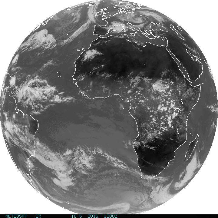
These pictures are great! I found very usefull pictures you promted from pamola.um.maine.edu. Aspecialy the first of them. They are not too large amount of data and give very good picture of weather aroud the world. I know that they are not too much detailed, but for world auditory it should fit the basic picture of weather. Image weather information is very important than to the word description of weather is not as good. When you look to weather satellite picture of weather you are in picture what weather really is. If you find more detailed weather satellite pictures with same amount of data it will be great! I am interestiong moustly about Europe, but other regions will be useful also certanly. Thank you. I will be gled if I found these pictures in my daily download from Outernet.
For example I would prefer these forecast images -
NOAA GOES Geostationary Satellite Server
It is small amount of data only 72kb.
I would be prefer this kind of weather picture form geostacionary weather satelittes. Please, please do it.
Next images can be found for example here.
1 Like
Yes, we disagree. I’d also love a local text report. But local to where? When you add up doing just the capital cities you get 196 ‘local’ reports. This quickly adds up and for many users (eg in Siberia) the capital city forecast is not useful at all, so you need to add in additional points. Even with 500 reports there will still be huge blackspots where the information is not that useful.
Likewise Gribs would be lovely, but only useful for a small subset of sailors, those who are outside of Navtex/ mobile phone range & too poor or cheap to get a SSB.
Yes these look really nice. Would be great to add them in IMHO.
They do give very limited info. Nothing on the windspeed, or temperature, but it is interesting to see the cloud cover & implied rainfall.
1 Like
This NOAA images from geostacionary sattelites are very important. From them they do forecast.
I dont need to much know exact temperature or wind, I can estimate them from picture. Direction of wind is moustly in general the same in the moustly regions. /not sailors/
But what is important is that that from this small amount of data 72kb you can estimate the global weather, also rain, temperature and wind. It very compressed and complex information in small amount of data.
1 Like
Outernet can break the weather information in the three world regions based on geographical coverage of the 3 Inmarsat satellites.
ie there is no point giving detailed Chinese weather to Europe.
I would like to know what is the total amount of Navtex text warnings sent out each day to all the worlds NAVTEX regions.
Navtex is sent every 4 hours to the worlds 20 or so regions and in special emegencies it is sent instantly.
As a text file this could be compressed and then decompressed by library.
I think sending Navtex maritime warnings could be a very good service for Outernet.
Outernet can break the weather information in the three world regions based on geographical coverage of the 3 Inmarsat satellites.
That would be good. I didn’t know they could @Syed could you confirm?
I would like to know what is the total amount of Navtex text warnings sent out each day to all the worlds NAVTEX regions.
Looks like the data is here: http://weather.gmdss.org/index.html
I think sending Navtex maritime warnings could be a very good service for Outernet.
It would be nice, but I think most people who would find the information useful have already spent a couple of hundred quid on a Navtex reciever.
I dont need to much know exact temperature or wind, I can estimate them from picture. Direction of wind is moustly in general the same in the moustly regions. /not sailors/
Many people do need to know this information though, will my wheat germinate if I plant it this week? Or will I lose my entire harvest to a late frost?
Do I need to issue an alert that people are at risk of freezing to death next week in the refugee camp I run?
But what is important is that that from this small amount of data 72kb you can estimate the global weather, also rain, temperature and wind. It very compressed and complex information in small amount of data.
I agree it’s useful and it would be great to add it to the broadcast, but I don’t personally think its sufficient on it’s own
1 Like
Yes, it is not sufficient on it’s own, but it will be great to have it in broadcast. All other weather information and maps which describes temparature, freezing etc. are very important also, and I will be glad to have it in Outernet broadcast.
1 Like
I went to the site and downloaded a text Navtex warning. It was approximately 2.7k.
I saved it and then compressed it to a zip file. It came to 1.2 k approx.
So there are approx 21 Meteorological Marine areas. They have a couple of reports per area.
So lets say 21 X 3 = 61 reports at 1.2 k is approx 80k of data every 4 hours for the Navtex service.
I think this could be viable for a Outernet service.
People in remote areas do go Fishing.
1 Like
Yes, I need this weather information because the harvest.
1 Like
Could a weather or other ALERT be loaded into the carousel immediately? First paused and then loaded with an alert which is appropriate, stating alert is for this area of world.
What about info from these pages into a text file (at least for the US).
http://www.nws.noaa.gov/xml/tpex/scs.php
or
http://www.nws.noaa.gov/data/WBN/SCS01
http://www.nws.noaa.gov/data/WBN/SCS02
http://www.nws.noaa.gov/data/WBN/SCS03
http://www.nws.noaa.gov/data/WBN/SCS04